Facts About Barbados
Geography – Barbados
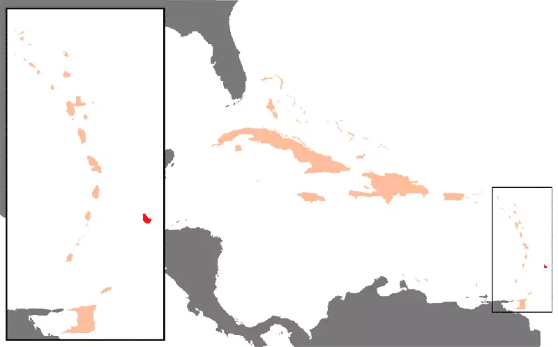
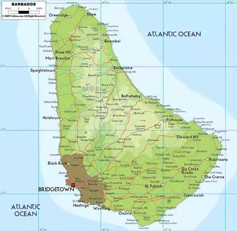
The island of Barbados lies at a unique position on the Atlantic Ocean on the East Coast, Eastern Caribbean of other West Indies islands at Latitude 13º10′ N & Longitude 59º 32′ W.
The island is one of the Lesser Antilles, a chain of islands in the English Caribbean.
Barbados is 14 miles wide and 21 miles long, with 166 square miles of beaches on the west and south coasts, forests, and some natural features that make it stand out.
Barbados’s territorial boundaries extend 12 nautical miles, but it enjoys an impressive 200 nautical miles of an exclusive economic zone.
Weather Of Barbados
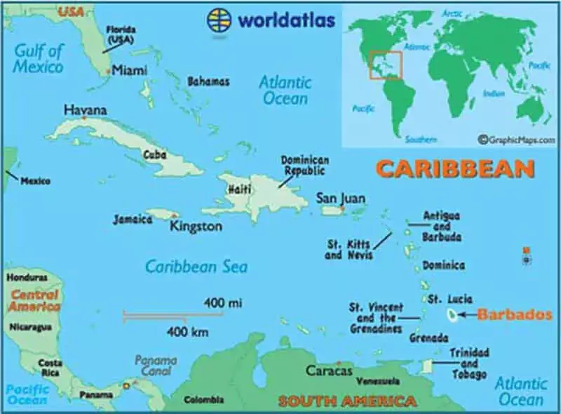
Barbados is a unique location in the Antilles, alongside the Bahamas, Trinidad, Cayman and Netherland Antilles, among other Caribbean islands. Because of its location in the North East of Venezuela, Barbados is not a part of the island’s Arc.
The island’s west coast is the Caribbean Sea, while the North and East coasts touch the Atlantic Ocean.
These coasts are known to be very turbulent, and with high waves accompanied by strong currents, something surfers scour the planet.
Interestingly, the west coast of Barbados island is very calm and barely gets bashed by the high seas. Because the cold front, which brings surfer’s waves, often comes during the summer and hurricane winds blow during the winter.
Land Formations And Geography
Barbados is a flat island that doesn’t share the extensive mountainous ranges as its neighbouring islands.
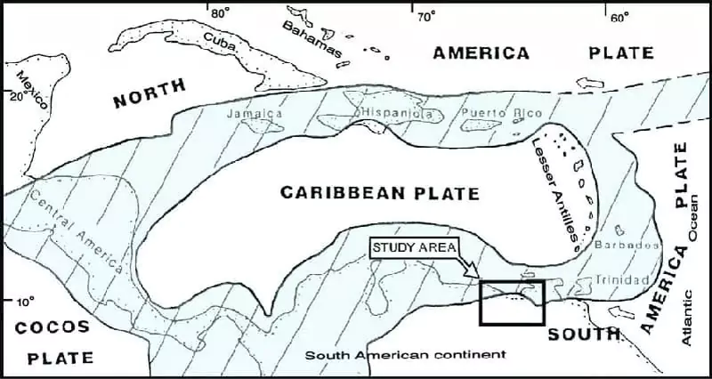
Science tells us that this is because Barbados is a coral island that gradually rose out of the sea. In contrast, its neighbours were pushed out of the seas by volcanic eruptions and others formed by the collision of tectonic plates.
Whatever the explanation, Barbados sits in the least dramatic location in the Caribbean Sea, with terraces beautifying the island’s edges. As it proudly displays the layered terraces bearing the scars of its gradual but progressive growth.
The island’s centre is generally a gentle slope over rolling hills that run parallel to the coast.
The land mass of Barbados island is about 85% coral limestone which is as much as 30 meters thick. Still, the surface has fertile soil insulating the rock beneath and necessitating fantastic natural and artificial vegetation overlooking the hills.
The island’s soil is fertile and arable and mainly used to grow sugarcane.
Towards the Atlantic end of the island is the Scotland District, an area with lots of coral rock cropping, especially along the beach.
Erosion is gradually eating away at the rock. The reason there has been a surge in cases of landslides and washouts over the past couple of decades.
The coral rocks have great water filtering benefits. When it rains, water sips through the coral rocks in the ground and is filtered naturally. As it makes its way through the underground mesh of reservoirs and caves, where it is harvested and pumped to homes.
The island of Barbados is known by many because of the white sandy beaches, unlike any others. The white colour is because of the coral reefs surrounding the islands, protecting its coastline.
Barbados: Towns Geography
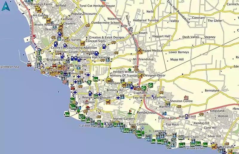
Bridgetown is one of the island’s most important cities. About half of the inhabitants live in island cities and towns, including Bridgetown.
Towns are ideal for visitors seeking to understand Barbados. Interacting with its people, immersing in its culture or enjoying the view will find something unique in a town in each of the four parishes.
The capital of Bridgetown is the Parish of St. Michael, Holetown, in the Parish of St. James. In the parish of Christ Church is Oistins, and the parish of St. peter is Speightstown.
The geography of the Barbados islands makes it easy to interconnect between these towns through interconnecting roads that run across the island.
However, because the road network in the islands is uncertain, navigating the roads can be pretty challenging for a visitor without a hang of it.
Most towns are on the coast because the roads grew as shipping ports mainly to England, the Caribbean Island and the Americas.
Today, these towns have evolved from shipping port economies into providers of tourism-based services.
Climate Of Barbados
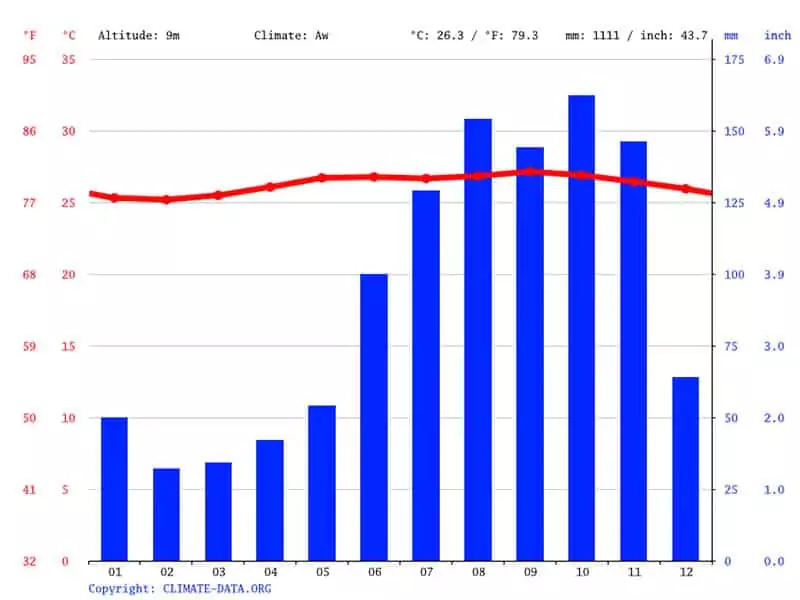
Image credits climate-data.org
If there is something that drives hordes of holidaymakers to Barbados every year, it is the immaculate Caribbean weather.
The period between December and June is a dry season with tropical island temperatures moderated by the blowing Northeast trade winds. The months between July and December are generally wet seasons, but this varies significantly depending on an area’s elevation.
At 1,120 feet, Mount Hillaby’s peak is the highest point on the island.
The annual temperature in Barbados ranges between 72.5 and 82.4 °F (24 to 28 °C), with more elevated areas throughout the country experiencing slightly lower temperatures.
The humidity is often stable at between 71 and 76 per cent throughout the year.
Its geographical location outside the Principal Hurricane Belt, Barbados, is not affected by the horrible effects of the tropical storms and hurricanes that often pound islands in the region.
The last major hurricane was Janet, a category three hurricane which hit the islands in 1955, leaving a trail of destruction and pain.
Country Description
Before the first British settlers arrived in 1627, Barbados island was uninhabited.
It has had a long island history since then. Still, it thrives and enjoys sufficient attention and regard globally because of tourism.
Sugar has always been the island’s primary driver of the Barbados economy.
Social and political reforms in the 1940s through 50s led to Barbados’s complete independence from the UK in 1966.
Barbados comes from the Portuguese word “los Barbados”, which means “bearded one.” The island is called so because of the signature bearded tree that once extensively covered the island.
Just like other islands in this part of the ocean, enslaved people worked the sugar plantations until slavery in 1834.
After the British abolished slavery, Barbados economy became heavily dependent on Sugar, Molasses and rum throughout most of the 20th century.
In the early 1990s, manufacturing and tourism surpassed the sugar industry as the country’s economic backbone.
Barbados Flag
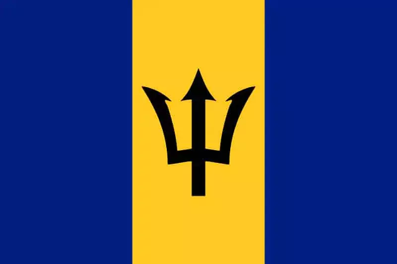
The flag of Barbados boasts three equal vertical stripes along the flag height: one gold/yellow stripe sandwiched between two blue stripes. The flag’s centre is a black trident head vertically facing up.
The first blue stripe on the left of the Barbados flag stands for the sky, the middle gold stands for the sand, and the right blue stripe signifies the blue sea.
The black trident at the centre of the flag is purposefully missing a handle because it represents the island’s break from England during independence, hence the reason it has only the top.
The trident has three points to represent the three principles of democracy: A government of the people, by the people for the people.
Coat Of Arms
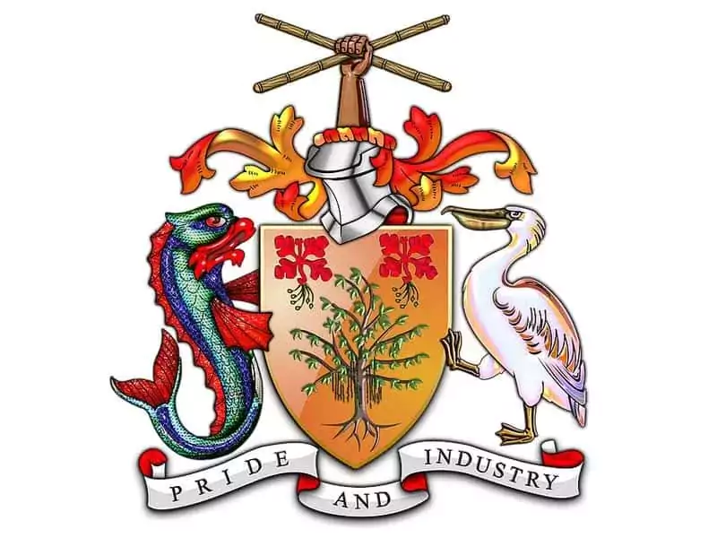
The most outstanding elements on the Barbados island coat of arms are two Pride of Barbados flowers and a bearded fig tree.
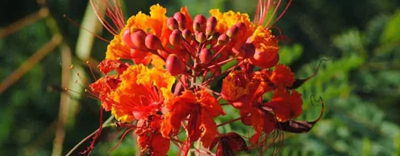
The Pride of Barbados, called Dwarf Poinciana or Flower Fence, is the island’s national flower. The focus Citrifolia tree is also called the bearded fig tree that gave the island its name Barbados.
Either side of the coat of arms has a pelican supporting the shield to the right while a dolphin holds the left.
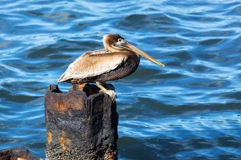
The pelican shows association with the smaller island of Pelican off the coast of Barbados that was integrated with the Deep Water Harbor development project, while the dolphin and flying fish symbolize the dominant fishing industry.
Above the shield supported by the dolphin and the Pelican are a helmet and a mantling with a protruding arm holding crossed sugarcane pieces.
The sugar cane is symbolic of the dominant sugar industry. At the same time, the formation, the cross, is satirical for the cross Saint Andrew been crucified.
Barbadians celebrate their independence on November 30th, also St. Andrew’s Day. The lower area of the coat of arms is the island’s Motto: “Pride and Industry”.
History Of The Grant Of Arms

Her Majesty Queen ELIZABETH II of England presented the grant of arms by royal warrant given to the President of the Senate of Barbados at the time on February 14th 1966, also considered the day of independence, during her visit to Barbados.
The island’s only other heraldic item was the Seal of Colony, representing the British Colony Sovereign in a chariot shell drawn by two sea horses through foam waves.
The current Barbados island coat of arms is the work of a prolific designer and writer who was the director of the Barbados Museum for close to 25 years.
He died aged 66 in 1973. His most famous works include articles in museum journals, local papers, and overseas publications.
Neville attended Harrison College in Barbados and Fitzwilliam College in Cambridge.
He served with the Royal Artillery during the war. Discharged, he worked as a dealer in antiques and as an assistant secretary in advertising at the Institute of Practitioners.
Neville designed the Barbados coat of arms after extensive research he conducted. At the same time, he studied at the Heraldy and got assistance from an excellent artist, the late Mrs Hilda Ince.
To his day, the original developmental sketches of the island’s coat of arms remain under the protection and care of the Barbados Museum and Historical Society.
Extracts From The Royal Warrant
“Know ye therefore that We of Our Price Grace and Special Favour have granted and assigned and by these Presents do grant and assign the following Armorial ensigns for Our Island of Barbados”:
For Arms: “Or a Bearded Fig Tree eradicated in Chief two Red Pride of Barbados Flowers proper.
And for the Crest; On a Wreath Or and Gules A dexter Cubit Arm of a Barbadian erect the hand of grasping two Sugar Canes in saltire proper.
Supporters: Dexter side- a Dolphin. Sinister side- a Pelican proper, Motto-“Pride and Industry”, identical in the painting hereunto annexed more plainly depicted the whole to be borne and used for our Island of Barbados – on Seals or Otherwise according to the Laws of Arms.”
Barbados National Pledge
“I pledge allegiance to my country Barbados and to my flag,
To uphold and defend their honour,
And by my living to do credit
To my nation, wherever I go”
National Anthem
In plenty and in time of need
When this fair land was young
Our brave forefathers sowed the seed
A pride that makes no wanton boast
From which our pride is sprung
That binds our hearts from coast to coast
Of what it has withstood
The pride of nationhood
Chorus
We loyal sons and daughters all
Do hereby make it known
These fields and hills beyond recall
Are now our very own
We write our names on history’s page
With expectations great
Strict guardians of our heritage
Firm craftsmen of our fate
The Lord has been the people’s guide
For past three hundred years
With him still on the people’s side
We have no doubts or fears
Upward and onward we shall go
Inspired, exulting, free
And greater will our nation grow
In strength and unity
- Land Area: 166 square miles (430 square km)
- Location: 13 10 N, 59 32 W
- Prime Minister: first female Prime Minister (Barbados Labour Party) Hon. Mia Armor Mottley
- Governor-General: Dame Sandra Mason
- Literacy rate: 97% (in 1995). Every child is allowed to attend school from 5 years old to 16.
- Climate: Tropical and rainy
- Terrain: Relatively flat rising gently to the central highland
- Natural Resources: Natural gas, Petroleum, Fish, Beaches, Vegetation
- Highest Elevation point: Mount Hillaby (336 m)
- Population (2021): 285,000 (growth rate at 0.3%)
- Currency Note: Barbados Dollar
- Official Language: English (Bajan, an English-African dialect, widely used)
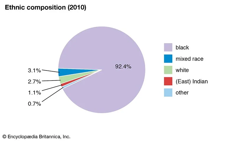
- Ethnicity / Race: Afro-Caribbean and mixed ethnicity of West African and mixed African-European descent. Black 92.4%, White 2.7%, Asian and mixed 5%
- Religions: Christianity -Protestant 67%; Roman Catholic 4%; none 17%; other 12%
- Natural Hazards: Infrequent hurricanes and periodic landslides
- Environmental Issues: Coastal waters pollution from waste disposal by ships; illegal solid waste disposal and soil erosion;
- Transportation & Highways: Total 1,600 km(1,600 km paved by 2003)
- Port and Harbor: Bridgetown
- The national dish of Barbados: Flying Fish and Cou Cou.
- National sport: Cricket
Interesting Barbados Facts:
- Land Area: 166 square miles (430 square km)
- Location: 13 10 N, 59 32 W
- Prime Minister: first female Prime Minister (Barbados Labour Party) Hon. Mia Armor Mottley
- Governor-General: Dame Sandra Mason
- Literacy rate: 97% (in 1995). Every child is allowed to attend school from 5 years old to 16.
- Climate: Tropical and rainy
- Terrain: Relatively flat rising gently to the central highland
- Natural Resources: Natural gas, Petroleum, Fish, Beaches, Vegetation
- Highest Elevation point: Mount Hillaby (336 m)
- Population (2021): 285,000 (growth rate at 0.3%)
- Currency Note: Barbados Dollar
- Official Language: English (Bajan, an English-African dialect, widely used)

- Ethnicity / Race: Afro-Caribbean and mixed ethnicity of West African and mixed African-European descent. Black 92.4%, White 2.7%, Asian and mixed 5%
- Religions: Christianity -Protestant 67%; Roman Catholic 4%; none 17%; other 12%
- Natural Hazards: Infrequent hurricanes and periodic landslides
- Environmental Issues: Coastal waters pollution from waste disposal by ships; illegal solid waste disposal and soil erosion;
- Transportation & Highways: Total 1,600 km(1,600 km paved by 2003)
- Port and Harbor: Bridgetown
- The national dish of Barbados: Flying Fish and Cou Cou.
- National sport: Cricket
FAQs About Barbados Fun Facts
Why is tourism important to Barbados?
Travel provides Barbados with the primary source of currency. From 1980 to 2000, it accounted for about 50 per cent of foreign exchange revenue.
Tourism is a crucial component of the gross domestic product in the United Kingdom. It has contributed to about a third of the total GDP since 1974.
What is unique about Barbados?
The only island of corals within the region consists of white sandy beaches. Barbados has pure drinking water, one of the first islands with piped water. Its ‘Telecommunications network’ is excellent. Barbados has a diverse cultural heritage and makes its islands unique.
How did Barbados get its name?
The only island of corals within the region consists of white sandy beaches. Barbados has pure drinking water, one of the first islands with piped water. Its ‘Telecommunications network’ is excellent. Barbados has a diverse cultural heritage and makes its islands unique.
Portuguese departed Barbados from Brazil to visit their home country.
The island is called the Spanish equivalent, “los Barbados,” then. Its name is a derivative of the island-wide fig trees with a beard-style appearance meaning ‘the bearded ones.
What food is popular in Barbados?
The most popular Barbados national cuisine is Coucou and fried flying fish. The second most popular are puddings and soups.
What is Barbados National Dessert?
Another Barbados nation dish, Conkie, is a dessert made on Independence Day to celebrate ending slavery and freedom from its mother country, England. This recipe uses freshly roasted pumpkin and coconut for the crust!
